Shahabad District was a historic district of Bihar and is no longer a separate administrative district today. Its former territory now forms parts of four districts: Bhojpur, Rohtas, Buxar and Kaimur. Historically, Shahabad was an important region of western Bihar, with its administrative headquarters at Arrah (Ara).
The region is famous for its connection with Sher Shah Suri, Kunwar Singh, the Battle of Buxar, Sasaram, Rohtasgarh, Bhojpuri culture and the Ganga-Son river system. The historical identity of Shahabad continues to be important in understanding the geography, history and culture of western Bihar.
Quick Information About Shahabad District

| Particular | Details |
| Historical District | Shahabad |
| State | Bihar |
| Historical Headquarters | Arrah (Ara) |
| Present Status | Former/Historical District |
| Historical Region | Western Bihar |
| Major Present Districts | Bhojpur, Rohtas, Buxar and Kaimur |
| Main Language | Bhojpuri |
| Other Languages | Hindi and regional languages |
| Major Rivers | Ganga, Son, Karmanasa and their tributaries |
| Famous For | Sher Shah Suri, Kunwar Singh, Buxar, Sasaram, Rohtasgarh and Bhojpuri culture |
| Important Historical Towns | Arrah, Sasaram, Buxar, Bhabua and Dehri |
The old Shahabad district covered a much larger area than any single present-day district. Its territory was gradually divided through administrative reorganisations, creating the four present districts of Bhojpur, Rohtas, Buxar and Kaimur.
Important PIN Codes in the Former Shahabad Region
Because Shahabad is no longer an administrative district, there is no single PIN code for the former district. PIN codes today belong to the four districts that occupy its historical territory.
| Area/Town | Present District | PIN Code |
| Arrah | Bhojpur | 802301 |
| Jagdishpur | Bhojpur | 802158 |
| Piro | Bhojpur | 802207 |
| Buxar | Buxar | 802101 |
| Dumraon | Buxar | 802119 |
| Sasaram | Rohtas | 821115 |
| Dehri | Rohtas | 821307 |
| Nokha | Rohtas | 802215 |
| Bhabua | Kaimur | 821101 |
| Mohania | Kaimur | 821109 |
| Ramgarh | Kaimur | 821110 |
| Chainpur | Kaimur | 821104 |
PIN codes should be checked according to the present district, town and individual post office before being used for official postal purposes.
Important Facts About Shahabad District
Here are some useful facts that make the historic Shahabad region distinctive:
- Shahabad was a historic district in western Bihar.
- Its historical headquarters was Arrah, now the headquarters of Bhojpur district.
- The old district was bifurcated in 1972 into Bhojpur and Rohtas.
- The former Shahabad territory was subsequently divided further to create Buxar and Kaimur.
- The four present districts occupying the former Shahabad territory are Bhojpur, Rohtas, Buxar and Kaimur.
- The region has a strong Bhojpuri linguistic and cultural identity.
- Sher Shah Suri had an important connection with Sasaram.
- Sher Shah Suri’s tomb at Sasaram is one of the region’s most famous monuments.
- Kunwar Singh, an important leader of the 1857 uprising, was associated with Jagdishpur in the former Shahabad region.
- The Battle of Buxar in 1764 was a major turning point in the history of British power in eastern India.
- Rohtasgarh Fort is an important historical and archaeological site.
- The region contains major rivers such as the Ganga and Son.
- Agriculture has traditionally been the economic foundation of the area.
- The region is known for Bhojpuri folk music, traditions and festivals.
- The historical Shahabad area remains culturally important even though the original district no longer exists.
Location and Geography of Shahabad District
Historically, Shahabad occupied a large portion of western Bihar. It extended from the Ganga in the north towards the Kaimur and Rohtas hills in the south.
The historical region was broadly associated with:
- Ganga River towards the north
- Son River towards the east
- Uttar Pradesh towards the west
- Kaimur and Rohtas plateau areas towards the south
Important geographical features include:
- Ganga floodplains
- Son River basin
- Karmanasa River
- Kaimur hills
- Rohtas plateau
- Agricultural plains
- Forested uplands
- Irrigation networks
- Rural settlements and fertile agricultural land
The geography helped Shahabad develop both agriculture and important historical settlements. The rivers also played a major role in transport, settlement and agriculture.
History of Shahabad District
Ancient History
The region of old Shahabad has a very long history. It was associated with the ancient Magadha region and later came under the influence of several major Indian kingdoms.
Archaeological and historical evidence indicates human settlement in the region from very early periods. The wider area was connected with the political and cultural development of ancient eastern India.
During the Mauryan period, the region formed part of the larger political sphere of Emperor Ashoka. Later, Gupta and other regional powers influenced the area.
Medieval Period
During the medieval period, the region came under different political authorities. The area became particularly important during the rise of Afghan and Mughal power in Bihar.
Sasaram became closely connected with the career of Farid Khan, later known as Sher Shah Suri. His family held land in the region, and Sasaram became the centre of his early political career.
Sher Shah Suri and Sasaram
Sher Shah Suri is one of the most important historical personalities associated with the former Shahabad region.
He established the Sur Empire in northern India and briefly occupied the imperial throne of Delhi. His administrative reforms, road system, revenue arrangements and currency reforms had a lasting influence.
His magnificent tomb at Sasaram remains one of the greatest monuments of the region.
Mughal Period
After the decline of the Sur dynasty, the area came under Mughal control. Bihar became an important province of the Mughal Empire, and Shahabad remained strategically important because of its location between eastern and northern India.
The region continued to develop through agriculture, local trade and administrative settlements.
Battle of Buxar
One of the most important historical events associated with Shahabad was the Battle of Buxar, fought in 1764.
The battle involved the forces of the British East India Company against the combined forces of Mir Qasim, Shuja-ud-Daula and Mughal Emperor Shah Alam II.
The British victory strengthened the East India Company’s political position in eastern India and became an important stage in the expansion of British rule.
British Period
During British rule, Shahabad was an important district of the Bengal Presidency and later Bihar.
The district was administered from Arrah and included a very large territory. Agriculture, land revenue administration and local zamindari systems played important roles in the economy.
Historical records from the British period provide detailed information about the area’s villages, land systems, roads, rivers, markets and social conditions.
Revolt of 1857
The region played a major role in the Indian Rebellion of 1857.
The most famous local leader was Babu Kunwar Singh of Jagdishpur. At an advanced age, he led forces against the British and became one of the most respected leaders of the uprising in Bihar.
His role has given Jagdishpur and the wider Shahabad region a special place in the history of India’s freedom struggle.
Formation of Present Districts
The original Shahabad district continued for many years after Independence.
In 1972, it was divided into Bhojpur and Rohtas. Later, further administrative changes resulted in the creation of Buxar and Kaimur.
The former Shahabad territory is therefore represented today by four separate districts:
- Bhojpur
- Rohtas
- Buxar
- Kaimur
Population of the Former Shahabad Region
Because Shahabad is no longer an administrative district, there is no current official population figure for Shahabad District as a separate district.
Population statistics today are recorded separately for Bhojpur, Rohtas, Buxar and Kaimur.
The region as a whole remains predominantly rural, with major urban centres including Arrah, Sasaram, Buxar, Dehri, Bhabua and Dumraon.
The region has a strong Bhojpuri cultural identity. Agriculture remains an important source of livelihood, while urban areas have developed through trade, education, transport, government services and small industries.
Economy of the Shahabad Region
The historical Shahabad region has traditionally been an agricultural area.
Major economic activities include:
- Agriculture
- Rice cultivation
- Wheat cultivation
- Pulses
- Oilseeds
- Sugarcane in suitable areas
- Livestock
- Food processing
- Small industries
- Retail and wholesale trade
- Transport
- Construction
- Government services
The fertile plains around the Ganga and Son river systems support agriculture. Irrigation from rivers, canals, reservoirs and groundwater has also contributed to agricultural production.
Agriculture in the Shahabad Region
Agriculture has historically been the backbone of the region’s economy.
Major crops include:
- Paddy
- Wheat
- Pulses
- Maize
- Oilseeds
- Sugarcane
- Vegetables
- Fruits
The Son Canal system has historically played an important role in irrigation in western Bihar.
Agricultural markets around Arrah, Buxar, Sasaram and other towns connect rural producers with larger trading centres.
Handloom and Traditional Industries
The Shahabad region has a rich tradition of Bhojpuri folk culture and rural craftsmanship.
Traditional activities include:
- Handloom work
- Pottery
- Bamboo and cane products
- Woodwork
- Metalwork
- Traditional food processing
- Folk music
- Folk theatre
Bhojpuri cultural traditions are especially prominent in festivals, weddings, village gatherings and religious events.
Industries and Business in the Shahabad Region
The region’s modern economy includes agriculture-based businesses, manufacturing, trade and services.
Important business centres include:
- Arrah
- Sasaram
- Buxar
- Dehri-on-Sone
- Bhabua
- Dumraon
Major economic activities include:
- Rice milling
- Food processing
- Agricultural trade
- Brick manufacturing
- Stone and mineral-related activities
- Small manufacturing
- Transport and logistics
- Retail markets
- Construction
- Tourism and hospitality
The region’s road and railway connectivity supports movement of agricultural products and other goods.
Education in the Shahabad Region
The former Shahabad region has developed an extensive network of schools, colleges and higher educational institutions.
Important educational centres include:
- Arrah
- Sasaram
- Buxar
- Bhabua
- Dehri
- Jagdishpur
- Dumraon
- Mohania
Veer Kunwar Singh University at Arrah is one of the most important higher education institutions in the region. It serves students from Bhojpur and neighbouring areas.
District Courts in the Former Shahabad Region
There is no single Shahabad District Court today because the historical district no longer exists administratively.
Judicial services are currently provided separately through the district courts of:
- Bhojpur — Arrah
- Rohtas — Sasaram
- Buxar — Buxar
- Kaimur — Bhabua
These courts handle civil, criminal and other judicial matters within their respective present-day district jurisdictions.
District Hospitals and Healthcare
Healthcare services are now organised separately in the four present districts.
Major healthcare centres include government hospitals and medical facilities in:
- Arrah
- Sasaram
- Buxar
- Bhabua
- Dehri
- Jagdishpur
- Dumraon
- Mohania
The region also has Community Health Centres, Primary Health Centres, private hospitals and nursing homes serving rural and urban populations.
Popular Tourist Attractions in the Former Shahabad Region
The historical Shahabad region has a large number of heritage and religious attractions.
- Sher Shah Suri’s Tomb, Sasaram
The Sher Shah Suri Tomb is one of the most famous monuments of Bihar. The grand mausoleum stands in the middle of a large water body and is an outstanding example of Afghan-style architecture.
It is closely connected with the history of the Sur dynasty and attracts visitors interested in medieval Indian history.
- Rohtasgarh Fort
Rohtasgarh Fort is a massive hill fort located in the Kaimur hill region. Its strategic location and extensive remains reflect the military importance of the area over many centuries.
The fort is one of the most significant heritage sites associated with the former Shahabad region.
- Buxar
Buxar is famous for the Battle of Buxar of 1764 and has considerable religious and historical importance.
The town is also associated with the Ganga and several temples and religious traditions.
- Jagdishpur
Jagdishpur is strongly associated with Babu Kunwar Singh, the famous leader of the 1857 uprising.
The town is an important destination for visitors interested in India’s freedom struggle and the history of Bihar.
- Arrah
Arrah, the historic headquarters of Shahabad and present headquarters of Bhojpur, is an important cultural and administrative centre.
It is associated with the history of Kunwar Singh and the Siege of Arrah during the 1857 uprising.
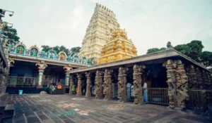
- Mundeshwari Devi Temple
Located in present-day Kaimur district, Mundeshwari Devi Temple is one of the important ancient temple sites of the region.
The temple is situated on the Mundeshwari hill and is notable for its historical, religious and architectural significance.
- Tarachandi Temple, Sasaram
Tarachandi Temple is an important religious site near Sasaram. It is located in a scenic hill environment and attracts devotees throughout the year.
- Chausa
Chausa in present-day Buxar district is associated with the Battle of Chausa of 1539, in which Sher Shah defeated Mughal emperor Humayun.
The site is important for visitors interested in the history of the Sur dynasty and Mughal India.
- Dehri-on-Sone
Dehri is an important town located along the Son River. The area has historical importance because of the development of irrigation, railways and river crossings.
The Son River landscape is also an important geographical feature of the region.
- Kaimur and Rohtas Hills
The southern part of the former Shahabad region contains the Kaimur and Rohtas hill landscapes.
The hills, forests, waterfalls, caves and historic sites provide opportunities for nature tourism, trekking and heritage exploration.
Transport and Connectivity
Road Connectivity
The former Shahabad region has strong road connections with Patna, Varanasi, Gaya, Sasaram, Arrah, Buxar, Bhabua and other parts of Bihar and neighbouring Uttar Pradesh.
Major national and state highways connect the principal towns and provide access to rural areas.
Railway Connectivity
Railway connectivity is an important strength of the region.
Major railway centres include:
- Arrah
- Buxar
- Sasaram
- Dehri-on-Sone
- Dumraon
- Bhabua Road
- Mohania
These railway routes provide connections towards Patna, Delhi, Varanasi, Kolkata, Gaya and other major cities, depending on the route and train service.
Air Connectivity
There is no major commercial airport within the former Shahabad region serving all four present districts.
For air travel, residents generally use airports such as Jay Prakash Narayan International Airport in Patna or Lal Bahadur Shastri International Airport in Varanasi, depending on their location and destination.
Best Time to Visit the Shahabad Region
The best time to explore the historical Shahabad region is generally October to March. The cooler weather is suitable for visiting forts, tombs, temples, archaeological sites and historical towns.
Winter is particularly comfortable for visiting:
- Sher Shah Suri’s Tomb
- Rohtasgarh Fort
- Arrah
- Jagdishpur
- Buxar
- Chausa
- Mundeshwari Temple
- Kaimur and Rohtas hills
The monsoon can make the hill regions greener, but access to some remote heritage and forest locations may become more difficult.
Nearby Cities, Districts and Areas
Important nearby cities and regions include:
- Patna
- Gaya
- Varanasi
- Chandauli
- Ballia
- Ghazipur
- Saran
- Aurangabad
- Palamu
- Garhwa
- Arrah
- Sasaram
- Buxar
- Bhabua
The historical Shahabad region occupies an important position between the Ganga plains, central Bihar, eastern Uttar Pradesh and the Kaimur-Rohtas highlands.
Why Is Shahabad District Important?
Although Shahabad is no longer a separate administrative district, its historical importance remains very strong.
Its major strengths include:
- Major role in the history of western Bihar
- Strong Bhojpuri cultural identity
- Association with Sher Shah Suri
- Sher Shah Suri’s Tomb at Sasaram
- Historical importance of Buxar and Chausa
- Contribution of Kunwar Singh to the 1857 uprising
- Important heritage site at Rohtasgarh
- Ganga and Son river systems
- Fertile agricultural plains
- Important religious and archaeological sites
The Shahabad legacy continues through the four present districts of Bhojpur, Rohtas, Buxar and Kaimur. Understanding the old district is useful for understanding the historical development of western Bihar and its Bhojpuri-speaking society.
FAQs About Shahabad District
Does Shahabad district still exist?
No. Shahabad is no longer a separate administrative district. Its former territory is now divided mainly among Bhojpur, Rohtas, Buxar and Kaimur districts.
What was the headquarters of Shahabad district?
The historic headquarters of Shahabad was Arrah, now known as Ara and serving as the headquarters of Bhojpur district.
When was Shahabad district divided?
The old Shahabad district was divided into Bhojpur and Rohtas in 1972. Further reorganisations later resulted in the creation of Buxar and Kaimur.
What was Shahabad district famous for?
Shahabad was famous for its Bhojpuri culture, agriculture, Sher Shah Suri’s connection with Sasaram, Kunwar Singh, Buxar and Rohtasgarh.
Which present districts were part of Shahabad?
The four major present districts occupying the former Shahabad territory are Bhojpur, Rohtas, Buxar and Kaimur.
Who was Kunwar Singh?
Babu Kunwar Singh was a prominent leader of the 1857 uprising against British rule. He belonged to Jagdishpur in the former Shahabad region.
Why is Sasaram important in Shahabad history?
Sasaram is closely associated with Sher Shah Suri and contains his famous tomb. It was also an important historical centre of the former Shahabad region.
Conclusion
Shahabad District belongs to the historical geography of western Bihar rather than the present administrative map. Its former territory is now divided among Bhojpur, Rohtas, Buxar and Kaimur, but its cultural and historical identity remains deeply rooted in the region.
The legacy of Shahabad is reflected in the monuments of Sasaram, the battlefield history of Buxar and Chausa, the freedom struggle of Kunwar Singh, the heritage of Rohtasgarh and the strong Bhojpuri traditions of western Bihar. Its rivers, agricultural plains, hills, temples and historic towns continue to make the former Shahabad region an important part of Bihar’s history and cultural landscape.