Arwal is a small but historically significant district in Bihar, located in the southern part of the state. The district is known for its agricultural economy, rural landscape, religious sites and location along the Son River.
Arwal town is the district headquarters. The district was created in 2001 after being separated from Jehanabad district. Agriculture remains the main source of livelihood, while road connectivity with Patna, Jehanabad, Aurangabad and Bhojpur gives Arwal regional importance.
Quick Information About Arwal District
| Particular | Details |
| District | Arwal |
| State | Bihar |
| District Headquarters | Arwal |
| Formation | 2001 |
| Area | About 638 sq. km |
| Population | 7,00,843 (Census 2011) |
| Literacy Rate | About 69.54% |
| Main Language | Hindi, Magahi |
| Major River | Son River |
| Main Occupation | Agriculture |
| Famous For | Son River, agriculture and religious heritage |
| Important Towns | Arwal, Kurtha, Karpi and Kaler |
Important PIN Codes in Arwal District
Arwal district has separate PIN codes for different towns, villages and post offices.
| Area / Town | PIN Code |
| Arwal | 804401 |
| Kaler | 804402 |
| Karpi | 804419 |
| Kurtha | 804421 |
| Sonbhadra Banshi Suryapur | 804402 |
| Wanshi | 804402 |
Arwal town, the district headquarters, uses PIN code 804401. Other villages and post offices have different PIN codes, so the exact locality should be checked when using a complete postal address.
Important Facts About Arwal District
Some useful facts about Arwal include:
- Arwal is located in southern Bihar.
- The district was formed in 2001.
- Arwal town is the district headquarters.
- It is one of the smaller districts of Bihar by geographical area.
- Agriculture is the main economic activity.
- The Son River is an important geographical feature.
- The district has a largely rural population.
- Hindi and Magahi are widely spoken.
- Arwal shares close economic and transport links with Jehanabad and other neighbouring districts.
- The district has fertile agricultural land.
- Paddy, wheat, pulses and vegetables are among the important crops.
- Kaler is known for its religious and historical significance.
- Arwal’s location provides road access towards Patna, Gaya, Aurangabad and Bhojpur.
Location and Geography of Arwal
Arwal is situated in the Magadh region of Bihar.
The district shares boundaries with:
- Jehanabad to the east
- Aurangabad to the west
- Bhojpur towards the northwest
- Patna to the north
- Gaya towards the south
The Son River forms an important part of the district’s western and northern geography.
The landscape is largely made up of fertile plains and agricultural land.
History of Arwal District
Arwal’s history is connected with the wider historical region of Magadh.
The region around present-day Arwal has been influenced by several major kingdoms and political powers that controlled Magadh and central Bihar over centuries.
The wider area has historical links with the Mauryan, Gupta and medieval dynasties, although Arwal itself developed primarily as a rural and agricultural region.
Formation of Arwal District
Arwal was separated from Jehanabad district in 2001 and became a separate administrative district.
The creation of the district was intended to make administration and government services more accessible to the local population.
Population of Arwal District
According to the 2011 Census, Arwal district had a population of approximately 7.01 lakh.
The district has a predominantly rural population.
Important population centres include:
- Arwal
- Kaler
- Karpi
- Kurtha
- Banshi
Agriculture and related activities provide livelihoods to a large part of the population.
Economy of Arwal District
Arwal has a primarily agriculture-based economy.
Major economic activities include:
- Agriculture
- Livestock
- Dairy
- Agricultural trading
- Retail
- Construction
- Transport
- Small businesses
Because the district has a relatively small urban base, agriculture continues to have a major influence on employment and local trade.
Agriculture in Arwal
Agriculture is the backbone of the district’s rural economy.
Major crops include:
- Paddy
- Wheat
- Maize
- Pulses
- Oilseeds
- Vegetables
The fertile plains and irrigation facilities support farming in several parts of the district.
The Son River and local irrigation systems are important for agricultural activities.
Industries and Business in Arwal
Arwal does not have a large industrial base.
Most businesses are small or medium-sized and are connected with the local rural economy.
Important business activities include:
- Agricultural trading
- Rice mills
- Food processing
- Dairy
- Retail
- Transport
- Construction
- Farm equipment
- Small manufacturing
There is potential for further development in agro-processing, storage, dairy and rural logistics.
Education in Arwal
Arwal has schools, colleges and educational institutions serving the local population.
Educational facilities are concentrated mainly around:
- Arwal
- Kaler
- Kurtha
- Karpi
For specialised higher education and professional courses, students often travel to Patna, Gaya, Jehanabad or other larger cities.
District Court in Arwal
Arwal has a District and Sessions Court serving the legal needs of the district.
The district judiciary handles civil, criminal and other legal matters.
Subordinate courts and legal services are also available for residents of different blocks.
District Hospital and Healthcare
Arwal has government healthcare infrastructure serving both urban and rural residents.
Important facilities include:
- District Hospital
- Community Health Centres
- Primary Health Centres
- Government health centres
- Private clinics
- Diagnostic facilities
The Sadar Hospital, Arwal is an important government healthcare facility.
For advanced specialised treatment, residents may travel to Patna, Gaya or other major medical centres.
Popular Tourist Attractions in Arwal District
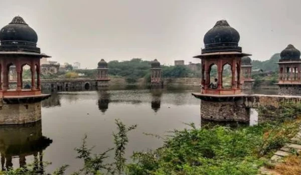
Arwal is not a major conventional tourist destination, but the district has several religious, historical and natural attractions.
- Kaleshwarnath Temple, Kaler
Kaleshwarnath Temple at Kaler is one of the better-known religious places in the district.
The temple attracts local devotees, particularly during important Hindu festivals.
- Kaler
Kaler is an important religious and historical area located near the Son River.
Its temples and rural surroundings make it a popular local destination.
- Son River
The Son River is one of the most prominent natural features of Arwal.
The river and its surrounding landscape are particularly attractive during the cooler months.
The river also plays an important role in agriculture and local livelihoods.
- Local Temples and Religious Sites
Several villages across Arwal have temples and shrines that are important to local communities.
Religious festivals and village fairs are an important part of the district’s cultural life.
Nearby Tourist Attractions
Because Arwal is close to several historically important districts, visitors can combine a trip with destinations outside the district.
Nearby attractions include:
- Bodh Gaya
- Nalanda
- Rajgir
- Patna
- Jehanabad
- Aurangabad
- Deo
These destinations offer a wider range of Buddhist, Hindu, historical and archaeological attractions.
Transport and Connectivity
Arwal has road connectivity with several important cities of Bihar.
Road Connectivity
Roads connect Arwal with:
- Patna
- Jehanabad
- Gaya
- Aurangabad
- Bhojpur
- Rohtas
- Other nearby districts
Road transport is the primary mode of travel within the district.
Railway Connectivity
Arwal does not have a major railway station in the town itself.
For train travel, residents commonly use railway stations in nearby districts, depending on the destination.
Jehanabad, Gaya and other nearby railway stations can be useful options.
Air Connectivity
The nearest major airport is Jay Prakash Narayan International Airport in Patna.
Patna Airport provides domestic air connectivity with several major Indian cities.
Best Time to Visit Arwal
The best time to visit Arwal is generally October to February.
The cooler weather is more comfortable for:
- Temple visits
- Rural sightseeing
- Exploring the Son River area
- Visiting nearby historical destinations
Summer can be hot, while monsoon conditions may affect travel in some rural areas.
Nearby Cities, Districts and Areas
Important nearby places include:
- Patna
- Jehanabad
- Gaya
- Aurangabad
- Bhojpur
- Rohtas
- Nalanda
- Rajgir
Arwal’s location in southern Bihar makes it relatively accessible to several major historical and administrative centres.
Why Is Arwal District Important?
Arwal is important because of its agricultural economy, location along the Son River and proximity to major historical and urban centres of Bihar.
Its major strengths include:
- Fertile agricultural land
- Son River
- Agricultural trade
- Religious sites
- Road connectivity
- Rural markets
- Proximity to Patna and Gaya
The district also has potential for agro-processing, food storage, dairy, rural businesses and tourism linked with nearby historical destinations.
FAQs About Arwal District
- What is Arwal district famous for?
Arwal is mainly known for agriculture, the Son River, Kaler’s religious heritage and its location in the Magadh region of Bihar.
- What is the district headquarters of Arwal?
Arwal town is the district headquarters.
- What is the PIN code of Arwal?
The main PIN code of Arwal town is 804401. Other towns and villages have different PIN codes.
- When was Arwal district formed?
Arwal became a separate district in 2001, after being separated from Jehanabad district.
- What are the popular places to visit in Arwal?
Popular local attractions include Kaleshwarnath Temple at Kaler, Kaler and the Son River area. Nearby districts also offer major historical and religious destinations.
- Does Arwal have a district court and district hospital?
Yes. Arwal has a District and Sessions Court and government healthcare infrastructure, including Sadar Hospital, Arwal, along with community and primary health centres.
Conclusion
Arwal District is a small but important district of southern Bihar, with an economy strongly connected to agriculture and rural trade. The Son River, fertile plains and religious sites give the district its distinctive character.
While Arwal itself is not among Bihar’s biggest tourist destinations, places such as Kaler and the Son River region offer opportunities for religious and local tourism. Its proximity to Patna, Gaya, Jehanabad, Aurangabad and other important destinations further increases its regional importance.
With continued development in agriculture, agro-processing, rural infrastructure, transport and local businesses, Arwal can play an increasingly important role in the economic development of southern Bihar.