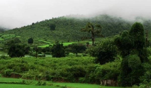
Nandurbar is a culturally rich district in Maharashtra, located in the northwestern part of the state. It is part of the Khandesh region and is known for its tribal heritage, Satpura hills, forests, agriculture, rivers and historic places.
The district has a strong tribal identity, with communities such as the Bhil, Pawara and Kokni contributing to its distinctive culture. Nandurbar is also known for Toranmal hill station, Prakasha temples, Dandpaneshwar Ganesh Temple and the Narmada River. Agriculture and forest-based livelihoods remain important to the local economy.
Quick Information About Nandurbar District
| Particular | Details |
| District | Nandurbar |
| State | Maharashtra |
| District Headquarters | Nandurbar |
| Formation | 1998 |
| Region | Khandesh |
| Area | About 5,955 sq. km |
| Population | 16,48,295 (Census 2011) |
| Literacy Rate | About 64.38% |
| Sub-Divisions | 2 |
| Tehsils | 6 |
| Main Languages | Marathi, Hindi and tribal languages |
| Major Rivers | Narmada, Tapi and Aner |
| Famous For | Tribal culture, Toranmal, Satpura hills, temples and agriculture |
| Important Towns | Nandurbar, Shahada, Taloda, Navapur and Akrani |
Nandurbar is one of Maharashtra’s predominantly tribal districts and has a distinctive social, cultural and geographical character.
Important PIN Codes in Nandurbar District
PIN codes are useful for postal services, online deliveries, business addresses and local searches. Some important areas include:
| Area / Town | PIN Code |
| Nandurbar | 425412 |
| Shahada | 425409 |
| Taloda | 425413 |
| Navapur | 425418 |
| Akkalkuwa | 425415 |
| Dhadgaon | 425414 |
| Toranmal | 425432 |
| Prakasha | 425422 |
| Khetia | 425424 |
| Khapar | 425416 |
PIN codes can differ between individual villages and post offices, so the exact post office should be checked when preparing a complete address.
Important Facts About Nandurbar District
Here are some useful facts that make Nandurbar distinctive:
- Nandurbar is located in northwestern Maharashtra.
- The district was created on 1 July 1998 after being separated from Dhule district.
- Nandurbar city is the district headquarters.
- The district is part of the historic Khandesh region.
- Nandurbar has a large Scheduled Tribe population.
- Major tribal communities include Bhil, Pawara and Kokni.
- Toranmal is one of Maharashtra’s well-known hill stations.
- The district is surrounded by parts of the Satpura mountain range.
- The Narmada River forms part of the northern boundary of the district.
- The Tapi River is another important river in the region.
- Prakasha is an important religious centre known for its ancient temples.
- Nandurbar has a strong agricultural and forest-based rural economy.
- The district shares boundaries with Gujarat and Madhya Pradesh.
- Tribal festivals, traditional dances, handicrafts and local customs are important parts of Nandurbar’s culture.
- The district has several forests, valleys, waterfalls and hill landscapes.
Location and Geography of Nandurbar
Nandurbar is located in the northwestern corner of Maharashtra.
The district shares boundaries with:
- Dhule district to the south
- Gujarat to the west and northwest
- Madhya Pradesh to the north
- Nashik region towards the southeast
The district’s geography is characterised by:
- Satpura hills
- Forests
- River valleys
- Agricultural plains
- Hilly tribal areas
- Rocky landscapes
The Narmada River forms an important northern geographical boundary, while the Tapi River flows through the wider Khandesh region.
The hilly areas around Akrani and Toranmal have a different landscape from the plains around Nandurbar and Shahada.
History of Nandurbar District
Nandurbar has a long historical connection with the Khandesh region.
Ancient and Medieval History
The wider Khandesh region was influenced by several dynasties, including the Yadavas, Faruqi rulers and later the Mughals and Marathas.
The region’s location between northern and western India made it an important route for trade and movement.
Nandurbar and the Freedom Movement
Nandurbar also has a notable connection with India’s freedom struggle.
One of the district’s most remembered freedom movement figures is Shirish Kumar, a young freedom fighter from Nandurbar who was killed during the Quit India Movement in 1942.
His sacrifice remains an important part of the district’s modern history.
Formation of Nandurbar District
Before 1998, Nandurbar was part of Dhule district.
On 1 July 1998, Nandurbar was created as a separate district.
The new district administration was established with Nandurbar town as its headquarters.
Population of Nandurbar District
According to the 2011 Census, Nandurbar had a population of approximately 16.48 lakh.
The district has a predominantly rural population.
A significant share of residents belong to Scheduled Tribe communities, making Nandurbar one of Maharashtra’s major tribal districts.
The literacy rate recorded in Census 2011 was approximately 64.38%.
Population distribution varies considerably between the plains and the remote hilly tribal areas.
Economy of Nandurbar District
Nandurbar’s economy is mainly based on:
- Agriculture
- Animal husbandry
- Forest produce
- Handicrafts
- Small businesses
- Trade
- Tourism
Agriculture is particularly important in the relatively fertile plains, while people in hilly areas often depend on agriculture combined with forest-based livelihoods.
Agriculture in Nandurbar
Agriculture is one of the main sources of employment.
Important crops include:
- Cotton
- Jowar
- Maize
- Wheat
- Bajra
- Groundnut
- Pulses
- Banana
- Sugarcane
- Vegetables
Banana cultivation is particularly important in parts of the Tapi valley.
The district also has livestock farming and dairy-related activities.
Forests and Tribal Economy
Forests are an important part of Nandurbar’s geography and rural economy.
Tribal communities traditionally depend on:
- Minor forest produce
- Agriculture
- Livestock
- Bamboo
- Mahua
- Tendu leaves
- Seasonal forest products
Traditional knowledge of forests and local biodiversity remains an important part of tribal life.
Industries and Business in Nandurbar
Nandurbar does not have a large heavy-industrial base, but agriculture and local trade support several businesses.
Major sectors include:
- Agro-processing
- Cotton-related businesses
- Food processing
- Rice and grain mills
- Oil processing
- Dairy
- Handicrafts
- Forest-based products
- Retail
- Transport
- Tourism
The district’s proximity to Gujarat and Madhya Pradesh also supports inter-state trade.
Education in Nandurbar
Nandurbar has schools, colleges and technical education institutions.
Important education centres include:
- Nandurbar
- Shahada
- Navapur
- Taloda
Higher education institutions in the district provide courses in arts, science, commerce, education and other fields.
Students from remote tribal areas also have access to government residential schools and other educational programmes designed for tribal communities.
District Court in Nandurbar
Nandurbar has a District and Sessions Court serving the district.
The district judiciary handles civil, criminal and other legal matters.
Subordinate courts and judicial institutions are also available in different parts of the district.
District Hospital and Healthcare
Nandurbar has government healthcare infrastructure serving both urban and rural communities.
Important facilities include:
- District Hospital, Nandurbar
- Sub-district hospitals
- Rural hospitals
- Community Health Centres
- Primary Health Centres
- Health sub-centres
Healthcare access remains particularly important in remote tribal and hilly areas, where distance and transportation can affect access to specialised medical services.
Popular Tourist Attractions in Nandurbar
Nandurbar offers a mix of hills, temples, rivers, forests and tribal culture.
- Toranmal
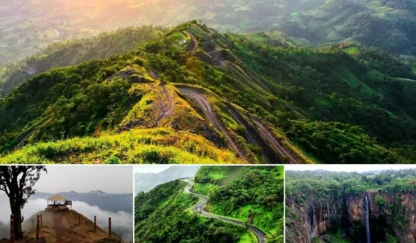
Toranmal is the most famous tourist destination in Nandurbar.
Located in the Satpura hills, Toranmal is known for:
- Hills
- Forests
- Lakes
- Valleys
- Waterfalls
- Pleasant weather
It is particularly popular during the winter and monsoon seasons.
- Yashwant Lake
Yashwant Lake is one of Toranmal’s scenic attractions.
The lake is surrounded by hills and greenery and provides a peaceful setting for visitors.
- Sita Khai
Sita Khai is a scenic valley and viewpoint in the Toranmal region.
The location offers views of deep valleys and surrounding Satpura landscapes.
- Prakasha
Prakasha is one of the most important religious destinations in Nandurbar.
It is sometimes called Dakshin Kashi because of its association with ancient temples and Shaivite traditions.
The Kedareshwar Temple is an important attraction in the area.
- Dandpaneshwar Ganesh Temple
The Dandpaneshwar Ganesh Temple in Nandurbar is a well-known religious site.
It attracts devotees throughout the year, particularly during Ganesh-related festivals.
- Narmada River
The Narmada forms part of the northern landscape of Nandurbar.
The river and surrounding areas are important from both environmental and cultural perspectives.
- Unapdev
Unapdev is known for its natural hot-water spring and is a popular local attraction.
The site combines natural features with religious significance.
- Shahada and Surrounding Temples
Shahada and nearby areas have several temples and religious sites that reflect the traditional culture of the region.
Transport and Connectivity
Nandurbar has road and railway connectivity with major cities of Maharashtra and neighbouring states.
Road Connectivity
Roads connect Nandurbar with:
- Dhule
- Nashik
- Surat
- Jalgaon
- Baroda
- Madhya Pradesh
- Other parts of Maharashtra
Its location close to Gujarat makes Nandurbar an important regional road-trade centre.
Railway Connectivity
Nandurbar Railway Station is an important station on the railway route connecting Maharashtra with Gujarat and northern India.
Rail services provide connections towards:
- Surat
- Mumbai
- Vadodara
- Bhusawal
- Delhi
- Other cities
Air Connectivity
The nearest major airports include:
- Vadodara Airport
- Surat Airport
Travellers can also use Chhatrapati Shivaji Maharaj International Airport, Mumbai, for wider domestic and international connectivity.
Best Time to Visit Nandurbar
The best time to visit Nandurbar is generally October to February.
These months are comfortable for exploring:
- Toranmal
- Temples
- Forts and heritage sites
- Forest areas
- Rural landscapes
Monsoon
The monsoon season is particularly attractive around Toranmal, when the hills become green and waterfalls become more active.
However, heavy rainfall can make hilly roads and remote areas difficult to access.
Nearby Cities, Districts and Areas
Important nearby places include:
- Dhule
- Shahada
- Navapur
- Taloda
- Surat
- Jalgaon
- Nashik
- Baroda
- Sendhwa
- Akkalkuwa
- Toranmal
Nandurbar’s border location gives it strong connections with both Gujarat and Madhya Pradesh.
Why Is Nandurbar District Important?
Nandurbar is important because of its combination of tribal heritage, agriculture, forests, hill tourism and religious sites.
Its major strengths include:
- Toranmal hill station
- Large tribal population
- Satpura landscape
- Narmada River
- Tapi River
- Prakasha temples
- Agricultural production
- Forest resources
- Gujarat and Madhya Pradesh connectivity
- Rich tribal culture
The district provides an important example of Maharashtra’s tribal, rural and hilly regions.
FAQs About Nandurbar District
When was Nandurbar district formed?
Nandurbar became a separate district on 1 July 1998, after being separated from Dhule district.
What is Nandurbar district famous for?
Nandurbar is famous for Toranmal hill station, tribal culture, Satpura hills, Prakasha temples, agriculture and the Narmada River.
What is the PIN code of Nandurbar?
The PIN code of Nandurbar is 425412. Different towns and villages have their own PIN codes.
What are the popular tourist places in Nandurbar?
Popular attractions include Toranmal, Yashwant Lake, Sita Khai, Prakasha, Dandpaneshwar Ganesh Temple and Unapdev.
What is the district headquarters of Nandurbar?
Nandurbar city is the district headquarters.
Does Nandurbar have a district court and district hospital?
Yes. Nandurbar has a District and Sessions Court and a District Hospital, along with rural hospitals, CHCs, PHCs and other healthcare facilities.
Conclusion
Nandurbar District is a distinctive part of Maharashtra, known for its tribal heritage, Satpura hills, agriculture, forests, religious sites and natural beauty.
The district’s most popular destination, Toranmal, attracts visitors with its hills, lakes, valleys and monsoon landscapes. At the same time, places such as Prakasha, Unapdev and Narmada river areas showcase its religious and natural heritage.
With its important tribal population, agricultural economy and strategic location near Gujarat and Madhya Pradesh, Nandurbar continues to hold an important place in Maharashtra’s cultural and economic landscape.