Eluru District is an important district in Andhra Pradesh, located in the coastal Andhra region. It is known for agriculture, aquaculture, Kolleru Lake, temples, tribal and forest areas, mangoes, handloom traditions and the developing Polavaram region.
The present Eluru district came into existence in 2022 after the reorganisation of the erstwhile West Godavari district along with areas transferred from the former Krishna district. Eluru city is the district headquarters. The district combines delta plains, upland areas and agency regions, giving it considerable geographical and economic diversity.
Quick Information About Eluru District
| Particular | Information |
| District | Eluru |
| State | Andhra Pradesh |
| District Headquarters | Eluru |
| Formation | 2022 |
| Area | 6,411.56 sq. km |
| Population | 20,02,658 (2011 Census, current district area) |
| Literacy Rate | 71.44% |
| Revenue Divisions | 3 |
| Mandals | 27 |
| Revenue Villages | 655 |
| Inhabited Villages | 624 |
| Gram Panchayats | 550 |
| Main Language | Telugu |
| Major Water Bodies | Kolleru Lake and river systems |
| Famous For | Kolleru Lake, Dwaraka Tirumala, Papikondalu, agriculture and mangoes |
| District Headquarters | Eluru |
Eluru district has a predominantly rural population. According to the district’s 2011 Census profile, about 80.70% of the population lived in rural areas, while around 19.30% lived in urban areas.
Important PIN Codes in Eluru District
The district has a wide postal network covering Eluru city, towns and rural areas.
| Area/Town | PIN Code |
| Eluru | 534001 |
| Eluru Collectorate | 534004 |
| Jangareddygudem | 534447 |
| Nuzvid | 521201 |
| Dwaraka Tirumala | 534426 |
| Chintalapudi | 534460 |
| Polavaram | 534315 |
| Koyyalagudem | 534312 |
| Buttayagudem | 534448 |
| Kamavarapukota | 534449 |
| Bhimadole | 534425 |
| Agiripalle | 521211 |
PIN codes can vary between individual villages and post offices, so the exact PIN should be verified for the complete postal address before sending official documents.
Important Facts About Eluru District
Here are some useful facts that make Eluru distinctive:
- Eluru is a district of Andhra Pradesh.
- The present district was created in 2022.
- Eluru city is the district headquarters.
- The district has three revenue divisions.
- It currently has 27 mandals.
- The district covers about 6,411.56 sq. km.
- The 2011 Census population for the present district area was 20,02,658.
- Kolleru Lake is one of the most important geographical features of the district.
- Dwaraka Tirumala is a major pilgrimage centre.
- Papikondalu can be accessed from the Eluru district side around Koruturu.
- Polavaram Project is an important regional irrigation and infrastructure project.
- Nuzvid is famous for its mango-growing region.
- Agriculture and aquaculture are major components of the local economy.
- The district includes delta, upland and agency geographical regions.
- Eluru has important road and railway connections with other parts of Andhra Pradesh.
Location and Geography
Eluru district is situated in the coastal Andhra region. Its geography changes from fertile agricultural and deltaic areas to upland and forested agency areas.
The district’s western side is influenced by the Tammileru River and Kolleru Lake, while the northern areas extend towards the forested and hilly landscapes associated with the Godavari region.
The district shares boundaries with:
- Alluri Sitharama Raju district towards the north and northeast
- NTR district towards the west
- Krishna district towards the southwest
- West Godavari district towards the east and southeast
- Khammam district of Telangana towards the northwestern side
The exact boundary arrangement reflects Andhra Pradesh’s recent district reorganisation, so current administrative maps should be used for detailed boundary-level information.
Important geographical features include:
- Kolleru Lake
- Tammileru River
- Yerrakaluva
- Eluru Canal
- Jalleru water system
- Delta plains
- Upland areas
- Agency and forest regions
- Agricultural fields and irrigation networks
The district’s combination of wetlands, agricultural plains and uplands supports a wide range of economic activities.
History of Eluru District
The history of the Eluru region is connected with the wider history of Coastal Andhra and the Godavari-Krishna region.
Ancient and Medieval Background
The wider region was influenced by several important South Indian dynasties, including the Satavahanas, Eastern Chalukyas, Kakatiyas and later regional kingdoms.
Its location between the Krishna and Godavari river systems supported agriculture, trade and cultural exchange.
Religious Heritage
The region around present-day Eluru has several important temples and pilgrimage centres. Dwaraka Tirumala, popularly associated with Lord Venkateswara, is among the most important religious destinations.
Several villages and towns in the district also preserve local temple traditions connected with Shaivism, Vaishnavism and village deities.
Colonial Period
During the colonial period, the region formed part of the administrative territories of the Madras Presidency. Eluru and surrounding areas developed agricultural and commercial connections with other towns along the coastal region.
Modern Administrative History
Eluru was historically associated with the former West Godavari district. During the Andhra Pradesh district reorganisation, the present Eluru district was created in 2022 by combining areas from the former West Godavari district with eight mandals from the former Krishna district.
The district administration began functioning under the new structure from 2022, with Eluru as its headquarters.
Population of Eluru District
According to the district’s official demographic profile based on the 2011 Census, Eluru district had a population of 20,02,658.
| Demographic Indicator | 2011 Figure |
| Total Population | 20,02,658 |
| Male Population | 10,00,269 |
| Female Population | 10,02,389 |
| Sex Ratio | 1,002 females per 1,000 males |
| Population Density | 312 persons/sq. km |
| Literacy Rate | 71.44% |
| Rural Population | 16,18,288 |
| Urban Population | 3,84,370 |
| Rural Share | 80.70% |
| Urban Share | 19.30% |
The district has a substantial Scheduled Caste and Scheduled Tribe population. The northern and agency areas have stronger tribal representation than the more densely cultivated delta regions.
Economy of Eluru District
Eluru’s economy is strongly connected with agriculture, aquaculture, horticulture, livestock, trade and services.
Major economic sectors include:
- Paddy cultivation
- Aquaculture
- Mango cultivation
- Oil palm
- Horticulture
- Fisheries
- Food processing
- Handloom and textiles
- Retail trade
- Transport
- Small-scale industries
- Tourism and hospitality
The availability of water resources and fertile agricultural land has supported intensive cultivation in several parts of the district.
Agriculture in Eluru District
Agriculture is one of the main economic activities in Eluru district. The fertile plains and irrigation systems support extensive cultivation.
Important crops and agricultural products include:
- Paddy
- Sugarcane
- Maize
- Pulses
- Oilseeds
- Mangoes
- Oil palm
- Vegetables
- Banana
- Coconut
Nuzvid is particularly associated with mango cultivation and trade. Paddy cultivation is also important in the delta and irrigated areas.
Aquaculture, including fish and shrimp farming, is an important part of the wider coastal economy.
Handloom and Traditional Industries
Eluru district has a mixture of traditional rural occupations and small industries.
Important activities include:
- Handloom weaving
- Textile-related work
- Bamboo and cane products
- Agricultural processing
- Food processing
- Cashew and other agro-processing activities
- Traditional handicrafts
- Fishing-related occupations
The district’s rural economy supports numerous small and household-level enterprises alongside larger agricultural and commercial businesses.
Industries and Business in Eluru District
Industrial and business activity in Eluru is closely associated with agriculture, food processing, trade and infrastructure.
Important sectors include:
- Food processing
- Rice mills
- Aquaculture
- Fisheries
- Mango processing
- Oil palm processing
- Construction
- Engineering and fabrication
- Transport and logistics
- Retail and wholesale trade
- Small and medium enterprises
Eluru city is the major commercial centre, while Nuzvid, Jangareddygudem, Chintalapudi and other towns serve as regional markets.
The Polavaram Project also has major regional importance because of its role in irrigation, water management and infrastructure development.
Education in Eluru District
Eluru is an important educational centre for the surrounding rural areas.
Educational infrastructure includes:
- Government schools
- Private schools
- Degree colleges
- Junior colleges
- Engineering and professional colleges
- Polytechnic institutions
- Teacher training institutions
- Health and medical education facilities
Eluru city has the largest concentration of educational and professional institutions in the district. Nuzvid and Jangareddygudem are also important educational centres.
District Court in Eluru
The District Court at Eluru provides judicial services for the district. Subordinate courts operate at appropriate locations to serve the population of different areas.
The judicial system handles civil, criminal and other legal matters under the broader judicial structure of Andhra Pradesh.
District Hospital and Healthcare
Eluru district has a government healthcare network covering urban and rural populations.
Important healthcare facilities include:
- District-level hospital services in Eluru
- Area and government hospitals
- Community Health Centres
- Primary Health Centres
- Sub-centres
- Urban health facilities
- Private hospitals and clinics
Healthcare infrastructure is particularly important in the rural and agency areas, where government health facilities provide primary and referral services.
Popular Tourist Attractions in Eluru District
Eluru district has a combination of pilgrimage centres, wetlands, forests, archaeological sites, rivers and scenic landscapes.
- Dwaraka Tirumala
Dwaraka Tirumala is one of the most important pilgrimage destinations in the district. The Sri Venkateswara Swamy Temple is popularly known as Chinna Tirupati and attracts devotees from Andhra Pradesh and neighbouring states.
- Kolleru Lake
Kolleru Lake is one of India’s important freshwater lakes and a major ecological feature of the region. It is located between the Krishna and Godavari delta systems.
The lake and surrounding wetlands support numerous bird species and are important for fisheries and local livelihoods.
- Papikondalu
The Papikondalu hill range can be approached from the Eluru district side, particularly around Koruturu. The scenic landscape along the Godavari River makes this region popular for nature and river tourism.
- Polavaram Project
The Polavaram Project is one of the major irrigation and multipurpose projects of Andhra Pradesh. The project and surrounding Godavari landscape are important from both an infrastructure and regional-development perspective.
- Guntupalli Caves
The Guntupalli Caves are an important archaeological and Buddhist heritage site. The rock-cut caves and associated remains provide evidence of the region’s ancient Buddhist traditions.
- Pattiseema
Pattiseema is located along the Godavari River and is known for its religious significance and scenic river environment. The Veerabhadra Swamy Temple is an important local pilgrimage attraction.
- Eluru City
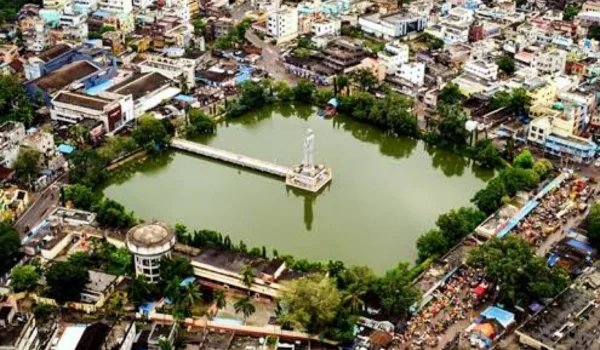
Eluru itself has historical and cultural attractions, including temples, traditional markets and the Abhaya Buddha statue. The city is also the main gateway for exploring several parts of the district.
- Nuzvid
Nuzvid is known for its mango orchards and agricultural heritage. During the mango season, the surrounding region becomes particularly active with fruit cultivation and trade.
- Koruturu
Koruturu is an important scenic destination in the northern part of the district and serves as an access point towards the Papikondalu landscape.
- Local Temples and Rural Heritage
Several villages and towns across Eluru district have historic temples and local religious sites. These destinations reflect the cultural traditions of rural Coastal Andhra.
Transport and Connectivity
Road Connectivity
Eluru has good road connectivity with Vijayawada, Rajamahendravaram, Tadepalligudem, Nuzvid, Jangareddygudem, Bhimavaram and other regional centres.
Major roads connect the district with neighbouring districts and the broader Andhra Pradesh road network.
Railway Connectivity
Eluru Railway Station is an important station on the major railway corridor connecting Vijayawada and Visakhapatnam.
Rail services provide connections to major cities in Andhra Pradesh and other parts of India.
Other railway stations in and around the district support regional travel.
Air Connectivity
The nearest major airport is Vijayawada International Airport, which provides domestic air connectivity.
The airport is useful for travellers visiting Eluru, particularly those arriving from major Indian cities.
Best Time to Visit Eluru District
The period from October to February is generally comfortable for exploring Eluru’s temples, wetlands, historical sites and natural attractions.
The winter months are particularly suitable for visiting Kolleru Lake, while the cooler season is also convenient for temple tourism and outdoor sightseeing.
Popular activities include:
- Visiting Dwaraka Tirumala
- Exploring Kolleru Lake
- Birdwatching around wetland areas
- Visiting Guntupalli Caves
- Exploring Papikondalu
- Visiting Polavaram
- Exploring Eluru city
- Experiencing local agricultural and food culture
Nearby Cities, Districts and Areas
Important nearby cities and regions include:
- Vijayawada
- Rajamahendravaram
- Tadepalligudem
- Bhimavaram
- Nuzvid
- Jangareddygudem
- Machilipatnam
- Khammam
- NTR district
- West Godavari district
- Alluri Sitharama Raju district
Eluru’s location between the Krishna and Godavari regions gives it considerable importance for agriculture, transport, trade and cultural exchange.
Why Is Eluru District Important?
Eluru is important because it combines agriculture, wetlands, pilgrimage, forest landscapes, aquaculture and regional infrastructure.
Its major strengths include:
- Important location in coastal Andhra
- Kolleru Lake and wetland ecosystem
- Fertile agricultural plains
- Strong paddy cultivation
- Important aquaculture activity
- Nuzvid mango-growing region
- Dwaraka Tirumala pilgrimage centre
- Guntupalli Buddhist heritage
- Papikondalu access and nature tourism
- Polavaram Project
- Growing urban and commercial centre at Eluru
- Strong road and railway connectivity
The district has a distinctive combination of delta agriculture, upland landscapes and agency areas, giving it economic and geographical diversity.
FAQs About Eluru District
When was Eluru district formed?
The present Eluru district was formed in 2022 during the Andhra Pradesh district reorganisation.
What is the headquarters of Eluru district?
Eluru city is the district headquarters.
How many mandals are there in Eluru district?
The current district administration lists 27 mandals.
What is Eluru district famous for?
Eluru is known for Kolleru Lake, Dwaraka Tirumala, Papikondalu, agriculture, aquaculture, Nuzvid mangoes and the Polavaram region.
What is the population of Eluru district?
According to the district’s 2011 Census profile for the present administrative area, Eluru district had a population of 20,02,658.
Which famous lake is located in Eluru district?
Kolleru Lake is one of the most important geographical and ecological attractions associated with Eluru district.
Which temple is known as Chinna Tirupati?
The Dwaraka Tirumala Sri Venkateswara Swamy Temple is popularly known as Chinna Tirupati.
Conclusion
Eluru District is a diverse district of Andhra Pradesh with a strong agricultural base, important wetlands, pilgrimage centres, forest landscapes and growing commercial activity. Its position between the Krishna and Godavari regions has historically supported agriculture, trade and cultural exchange.
From Kolleru Lake and Dwaraka Tirumala to Guntupalli Caves, Papikondalu, Pattiseema and the Polavaram region, Eluru offers a combination of natural, religious, archaeological and economic attractions. Its rural economy, transport connectivity and strategic location make it an important district in present-day Andhra Pradesh.