CG District commonly refers to districts of Chhattisgarh (CG), a central Indian state formed on 1 November 2000 after separation from Madhya Pradesh. Chhattisgarh is known for its forests, tribal heritage, mineral resources, agriculture, rivers, waterfalls, temples and rapidly developing industrial centres.
As of 2026, Chhattisgarh has 33 districts grouped into 5 administrative divisions. The districts range from highly urbanised areas such as Raipur and Durg to forested and tribal regions such as Bastar, Sukma, Bijapur and Narayanpur.
Quick Information About CG Districts
| Particular | Information |
| State | Chhattisgarh |
| State Code | CG |
| Number of Districts | 33 |
| Number of Divisions | 5 |
| State Capital | Raipur |
| Formation of State | 1 November 2000 |
| High Court | Chhattisgarh High Court, Bilaspur |
| Main Languages | Hindi, Chhattisgarhi and various tribal languages |
| Major Rivers | Mahanadi, Shivnath, Hasdeo, Indravati, Arpa, Kharun |
| Major Economic Activities | Agriculture, mining, steel, power, manufacturing, forestry and services |
| Famous For | Tribal culture, forests, waterfalls, temples, minerals, rice and steel industry |
| Important Cities | Raipur, Bilaspur, Durg, Bhilai, Korba, Raigarh, Jagdalpur, Rajnandgaon |
The state’s 33-district administrative structure includes both older districts and newer districts created to improve administration and bring government services closer to local populations.
Complete List of CG Districts
The current districts of Chhattisgarh are:
- Balod
- Baloda Bazar-Bhatapara
- Balrampur-Ramanujganj
- Bastar
- Bemetara
- Bijapur
- Bilaspur
- Dantewada
- Dhamtari
- Durg
- Gariaband
- Gaurela-Pendra-Marwahi
- Janjgir-Champa
- Jashpur
- Kabirdham (Kawardha)
- Kanker
- Khairagarh-Chhuikhadan-Gandai
- Kondagaon
- Korba
- Korea
- Mahasamund
- Manendragarh-Chirmiri-Bharatpur
- Mohla-Manpur-Ambagarh Chowki
- Mungeli
- Narayanpur
- Raigarh
- Raipur
- Rajnandgaon
- Sakti
- Sarangarh-Bilaigarh
- Sukma
- Surajpur
- Surguja
The latest five districts were created in 2022: Mohla-Manpur-Ambagarh Chowki, Sakti, Sarangarh-Bilaigarh, Manendragarh-Chirmiri-Bharatpur and Khairagarh-Chhuikhadan-Gandai.
Important Facts About CG Districts
Here are some useful facts that make the Chhattisgarh district system distinctive:
- Chhattisgarh became a separate state on 1 November 2000.
- The state currently has 33 districts.
- These districts are administered through 5 divisions.
- Raipur is the state capital and one of its major commercial centres.
- Bilaspur is an important administrative, judicial and railway centre.
- The Chhattisgarh High Court is located in Bilaspur.
- Bastar is internationally known for its tribal traditions, forests and handicrafts.
- Korba is an important centre for coal mining and power generation.
- Bhilai in Durg district is famous for its major steel industry.
- Chhattisgarh is one of India’s important rice-producing regions.
- The state has large deposits of coal, iron ore, limestone, bauxite and other minerals.
- Several southern districts have extensive forest cover and strong tribal cultural traditions.
- New districts were created in recent years to improve administrative accessibility.
- Major tourism attractions include Chitrakote Falls, Tirathgarh Falls, Sirpur, Barnawapara, Bhoramdeo and Mainpat.
- The state has important pilgrimage centres such as Rajim, Dongargarh and Bhoramdeo.
Location and Geography
Chhattisgarh is located in central India. It shares boundaries with Madhya Pradesh, Maharashtra, Telangana, Andhra Pradesh, Odisha, Jharkhand and Uttar Pradesh.
The state shares boundaries with:
- Madhya Pradesh towards the northwest and west
- Maharashtra towards the southwest
- Telangana towards the south
- Andhra Pradesh towards the southeast
- Odisha towards the east
- Jharkhand towards the northeast
- Uttar Pradesh towards the north
Important geographical features include:
- Mahanadi river basin
- Northern hills and plateaus
- Bastar plateau
- Extensive forest regions
- Hasdeo and Shivnath river systems
- Indravati river basin
- Fertile agricultural plains
- Mineral-rich areas of central and eastern Chhattisgarh
The geography of the state changes considerably from the northern hills to the central plains and the forested plateau of Bastar.
History of Chhattisgarh Districts
The history of the present-day districts of Chhattisgarh is closely connected with ancient kingdoms, tribal communities, medieval dynasties and the former Central Provinces.
Ancient and Medieval History
The region has a long history associated with Dakshina Kosala, an ancient geographical and cultural region. Archaeological and religious sites such as Sirpur provide evidence of important Buddhist, Hindu and Jain traditions.
During different periods, areas of present-day Chhattisgarh were ruled by dynasties including the Sharabhapuriya, Panduvamshi, Kalachuri and Nagavanshi rulers.
Kalachuri Influence
The Kalachuris of Ratanpur played an important role in the medieval history of the region. Ratanpur became a major political and cultural centre.
Maratha and British Period
Later, parts of the region came under Maratha influence and subsequently British administration. The territory was incorporated into administrative arrangements associated with the Central Provinces.
Formation of Chhattisgarh
Chhattisgarh became a separate state on 1 November 2000 under the Madhya Pradesh Reorganisation process.
Since state formation, several new districts have been created to improve administration and regional development.
Population of CG Districts
The population of Chhattisgarh’s districts varies significantly. The 2011 Census remains the principal official population benchmark for district-level demographic comparisons, while newer administrative boundaries have changed in some areas since then.
Major urban populations are concentrated around Raipur, Bhilai-Durg, Bilaspur, Korba, Raigarh and Rajnandgaon.
Southern and northern districts generally have larger rural and forest-dependent populations, with several districts having substantial tribal populations.
Economy of Chhattisgarh Districts
The economy of Chhattisgarh is based on a combination of agriculture, mining, manufacturing, power generation, forestry, trade and services.
Major economic sectors
- Agriculture and rice cultivation
- Coal mining
- Iron ore mining
- Steel production
- Cement manufacturing
- Electricity generation
- Forest-based activities
- Food processing
- Handicrafts
- Construction
- Retail and wholesale trade
- Transport and logistics
- Tourism and hospitality
Raipur, Durg-Bhilai, Korba, Bilaspur and Raigarh are among the important economic centres.
Agriculture in CG Districts
Agriculture remains an important source of livelihood across much of Chhattisgarh. The state is popularly associated with rice cultivation, and large parts of the central plains are suitable for paddy farming.
Other crops include:
- Wheat
- Maize
- Pulses
- Oilseeds
- Vegetables
- Fruits
- Sugarcane
- Minor millets
Forest produce also plays an important role in several districts. Tendu leaves, tamarind, mahua and other non-timber forest products support many rural and tribal households.
Handloom and Traditional Industries
Chhattisgarh has a strong tradition of tribal crafts and rural handicrafts.
Important traditional activities include:
- Bell-metal craft
- Dhokra metalwork
- Bamboo crafts
- Wood carving
- Tribal jewellery
- Handloom weaving
- Terracotta work
- Traditional textiles
Bastar is especially recognised for its metal crafts, woodwork and tribal handicrafts.
Industries and Business in CG Districts
Chhattisgarh is one of India’s important mineral and industrial states.
Major industrial centres
Raipur: Steel, engineering, trading, construction, services and logistics.
Bhilai-Durg: Steel, engineering and supporting industries.
Korba: Coal mining and power generation.
Raigarh: Steel, power, coal and related industries.
Bilaspur: Trade, services, railways, education and regional administration.
The state also has numerous MSMEs involved in manufacturing, food processing, engineering, transport, construction and local trade.
Education in Chhattisgarh
Chhattisgarh has a growing higher-education network with universities, engineering institutions, medical colleges, agricultural institutions and professional colleges.
Important education centres include:
- Raipur
- Bilaspur
- Durg-Bhilai
- Jagdalpur
- Korba
- Ambikapur
- Rajnandgaon
The state also has institutions focused on engineering, medicine, agriculture, tribal studies and other professional disciplines.
District Courts in CG Districts
District and subordinate courts operate across Chhattisgarh under the judicial system of the state. They handle civil, criminal and other matters at the district and subordinate levels.
The Chhattisgarh High Court is located at Bilaspur and serves as the state’s highest court.
District courts are available in major administrative centres, while additional courts and judicial establishments serve different regions.
District Hospitals and Healthcare
Healthcare infrastructure is distributed through district hospitals, community health centres, primary health centres and other government facilities.
Major urban centres such as Raipur, Bilaspur, Durg-Bhilai and Jagdalpur have larger healthcare networks, including specialist and teaching institutions.
Rural and tribal districts depend significantly on district hospitals, CHCs, PHCs and mobile or outreach healthcare services.
Popular Tourist Attractions in Chhattisgarh
Chhattisgarh’s districts offer a combination of waterfalls, forests, temples, archaeological sites and tribal heritage.
- Chitrakote Falls
Located in Bastar, Chitrakote Falls is one of the most famous waterfalls in Chhattisgarh. The horseshoe-shaped waterfall is created by the Indravati River.
- Tirathgarh Falls
Tirathgarh Falls is located in the Kanger Valley region of Bastar. Its multi-level waterfall and surrounding forest make it an important nature tourism destination.
- Sirpur
Sirpur in Mahasamund district is an important archaeological and religious site. It is known for ancient temples and remains representing Hindu, Buddhist and Jain traditions.
- Bhoramdeo Temple
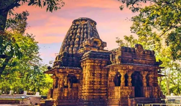
Located in Kabirdham district, the Bhoramdeo Temple complex is famous for its historic architecture and detailed stone carvings.
- Rajim
Rajim is an important religious centre known for its temples and the Rajim Kumbh Kalp religious gathering.
- Mainpat
Mainpat in northern Chhattisgarh is a scenic plateau known for its cool climate, forests, valleys and natural attractions.
- Barnawapara Wildlife Sanctuary
Located in the Mahasamund region, Barnawapara is known for forests and wildlife and is an important destination for nature lovers.
- Dongargarh
Dongargarh in Rajnandgaon district is famous for Maa Bamleshwari Temple, located on a hill and visited by large numbers of devotees.
- Kanger Valley National Park
This protected area in Bastar is known for dense forests, caves, wildlife and natural landscapes.
- Sirpur and Mahanadi Heritage Region
The wider Sirpur area combines archaeological heritage, religious monuments and the landscape of the Mahanadi region.
Transport and Connectivity
Road Connectivity
Chhattisgarh has an extensive road network connecting district headquarters, major towns, industrial centres and neighbouring states.
Raipur is the principal road transport hub. National and state highways connect the central districts with Madhya Pradesh, Maharashtra, Odisha, Telangana and Jharkhand.
Railway Connectivity
Railways are particularly important for passenger movement, coal transportation and industrial logistics.
Important railway centres include:
- Raipur
- Bilaspur
- Durg
- Bhilai
- Korba
- Raigarh
- Rajnandgaon
- Champa
Bilaspur is one of the most important railway centres in the region.
Air Connectivity
Swami Vivekananda Airport in Raipur is the major commercial airport serving the state. Air connectivity has also expanded through regional airports and airstrips serving selected cities.
Best Time to Visit Chhattisgarh
The best time to explore most parts of Chhattisgarh is generally during the cooler months from October to February. This period is suitable for sightseeing, wildlife tourism, waterfalls, temples and outdoor travel.
For waterfall destinations such as Chitrakote and Tirathgarh, the post-monsoon season can provide attractive scenery and stronger water flow, although local weather and access conditions should be checked before travelling.
Popular activities include:
- Visiting waterfalls
- Exploring tribal culture
- Temple tourism
- Wildlife tourism
- Archaeological sightseeing
- Forest excursions
- Exploring local handicrafts
Nearby States, Cities and Regions
Important nearby cities and regional centres include:
- Nagpur, Maharashtra
- Jabalpur, Madhya Pradesh
- Sambalpur, Odisha
- Rourkela, Odisha
- Ranchi, Jharkhand
- Hyderabad region, Telangana
- Gondia, Maharashtra
- Balaghat, Madhya Pradesh
- Varanasi region, Uttar Pradesh
The location of Chhattisgarh gives it strategic importance for central and eastern Indian trade, mineral transportation, agriculture and industrial development.
Why Are CG Districts Important?
Chhattisgarh’s districts are important because they collectively represent a strong combination of natural resources, agriculture, industry, tribal culture and tourism.
Its major strengths include:
- Rich mineral resources
- Large forest areas
- Important rice-producing regions
- Major steel and power industries
- Strong tribal heritage
- Important archaeological sites
- Waterfalls and wildlife destinations
- Growing urban centres
- Extensive road and railway networks
- Expanding administrative infrastructure
The creation of new districts has also helped bring administration and public services closer to smaller towns and rural communities.
FAQs About CG Districts
How many districts are there in Chhattisgarh in 2026?
Chhattisgarh has 33 districts as of 2026.
How many divisions are there in Chhattisgarh?
The state has 5 administrative divisions.
When was Chhattisgarh formed?
Chhattisgarh became a separate state on 1 November 2000.
Which is the capital of Chhattisgarh?
Raipur is the capital of Chhattisgarh.
Which district is famous for Bastar tourism?
Bastar district is famous for tribal culture, forests, Chitrakote Falls, Tirathgarh Falls and Kanger Valley National Park.
Which district is famous for steel production?
Durg district, particularly the Bhilai area, is one of the state’s major steel-producing regions.
Where is the Chhattisgarh High Court located?
The Chhattisgarh High Court is located in Bilaspur.
Conclusion
The CG districts of Chhattisgarh together form a diverse administrative and geographical region with fertile plains, forests, mineral-rich areas, industrial cities and tribal landscapes. From Raipur and Bilaspur to Bastar, Korba, Surguja and the newer districts, each area has its own economic and cultural identity.
Chhattisgarh is important for its agriculture, mining, steel, power, forests, tribal heritage and tourism. Its 33-district administrative structure continues to support regional development while preserving the distinctive history, culture and geography of central India.